Map, Analyze & Export Geospatial Data with Precision.
Create vectors, query Google sea-level elevations, transform Lambert projection coordinates, and export production-ready DXF, KML, and TXT files for AutoCAD & GIS.
Enterprise-grade geospatial infrastructure powered by:
Everything You Need for Professional Topography
Built for surveyors, civil engineers, and GIS professionals to streamline surveying workflows from field capture to CAD output.
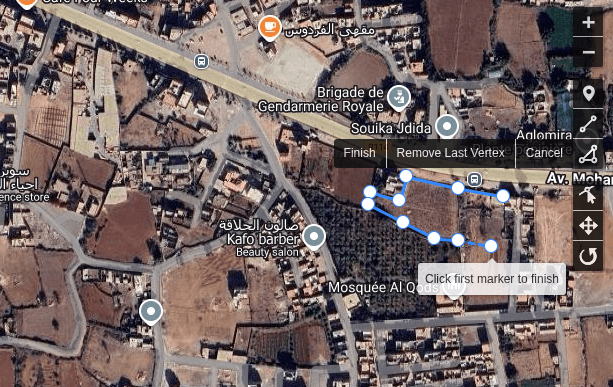
Precision Geometry & Geoman Drawing
Draw and interactively edit Points, Lines, Polygons, and Text markers. Real-time vertex manipulation with instant database synchronization.
Google Maps Elevation API Integration
Automatically retrieve sea-level elevations (Z) for every point and vertex with sub-meter resolution, generating 3D-ready spatial features.
Morocco Lambert Zones 1-4 Projections
Native Proj4 mathematical conversion between global WGS84 GPS coordinates and official Moroccan Lambert Conformal Conic grids.
AutoCAD DXF, Google KML & Topo TXT
Export full 3D topographic survey plans directly into AutoCAD with correct elevation tags, layered structures, and GPS points.
Rich Styled Text & Labels
Place dynamic text labels on the map with customizable typography, colors, padding, and borders that stay preserved during drag.
High-Resolution Satellite & Hybrid Imagery
Toggle between Esri World Imagery, Google Maps Satellite, OpenStreetMap, and Topographic terrain tiles for deep field analysis.
How MapsGis Works
From raw geospatial coordinates to production-grade CAD topography drawings in seconds.
Digitize or Import
Draw points, polylines, polygons, and text directly on satellite maps, or upload existing GPS coordinate lists and DXF/KML files.
Fetch Elevation (Z)
The system automatically queries Google Maps Elevation API for precise sea-level altitudes for every vertex and marker on the map.
Project into Lambert Grids
Instant mathematical coordinate conversion from WGS84 GPS degrees to official Morocco Lambert metric coordinates (Zones 1, 2, 3, or 4).
Export Production CAD
Download layered AutoCAD DXF files complete with 3D elevations, KML for Google Earth, and formatted TXT data for total stations.
Engineered for High-Precision Topography
Explore the dedicated tools that make MapsGis the fastest way to survey, digitize, and generate CAD plans.
Direct Export to DXF, KML, and Topo TXT
Generate clean AutoCAD DXF drawing files formatted with separate layers for points, polylines, polygons, and text labels. Includes sea-level elevation (Z) for every vertex and full Lambert projection coordinates.
Built for Geospatial & CAD Professionals
Whether you are a land surveyor on site or an engineer in the design office, MapsGis fits your workflow.
Topographers & Surveyors
Digitize land parcels, query terrain elevations, convert to Moroccan Lambert grids, and export directly to AutoCAD DXF files ready for client delivery.
Civil & Infrastructure Engineers
Trace pipeline corridors, road alignments, and construction perimeters while instantly calculating area, perimeter, and elevation changes.
Urban Planners & Architects
Overlay zoning boundaries on high-resolution satellite imagery, annotate masterplans with custom styled text, and share with teams.
GIS & Environmental Analysts
Manage multi-layer thematic vector datasets, import GPS tracklogs and KML files, and export unified GIS packages in seconds.
Frequently Asked Questions
Find answers to common questions about CAD exports, projections, elevation accuracy, and GIS workflows.